
Retracing the steps of Bishop Dom Salvado, the Camino Salvado trail of approximately 230kms stretches between St Joseph’s church in Subiaco and the Abbey Church in New Norcia. The trek can be tackled from either trailhead for those taking on an end to end adventure. With access points along the the way it is possible to jump on the trail for a day or a section. The trail can either be walked or cycled. History tells us Bishop Dom Salvado migrated from Spain to minister and mentor the indigenous community of the era. He walked the trek from New Norcia to commune with the Bishop at Subiaco. For a detailed account google http://www.newnorcia.com
A General Outline of the Trail
Departing from St Josephs church in Subiaco the shared path leads you out of suburbia via East Perth towards Guildford. A city map or google maps would be of benefit as there are a few routes that can be followed.
Once in Guildford, pass by Alfred’s Kitchen, turn left into Meadow St then cross over the rail crossing. Continue straight ahead noting the tourist info centre on the right as is Swan St should you wish to wander down to the eateries. Continue straight through the roundabout along Meadow St which eventually merges into West Swan Rd. If your accommodation for the night is at Benara Holiday Park leave the route and veer left at Benara Rd. There is a 7/11 store on the corner for any last minute supplies. 24kms
Continuing on West Swan Rd traverse through the Reid Hwy intersection to the Swan Valley region. An opportunity awaits to indulge in gourmet food, fine wine and great coffee before hitting the bush. BnB accommodation is plentiful along with the Swan Valley Caravan Park.
Leaving West Swan Rd turn right into Douglas Rd. which is mid way along. Continuing on for about 500mts veer right onto the shared path which weaves over Swan River bridge and continues onto Barrett Rd leading to the Great Northern Hwy where you turn left.
Follow the shared path along the Great Northern Highway passing by a cafe/general store. Leaving the highway turn right at Cathedral Ave continuing on to Bells Rapids. 23kms
With the river now in sight continue through the car park, if you’re in luck the coffee van maybe parked up. There are toilets within this area. Cross over the wooden bridge, veer right and at last the first trail marker is a welcome sight. 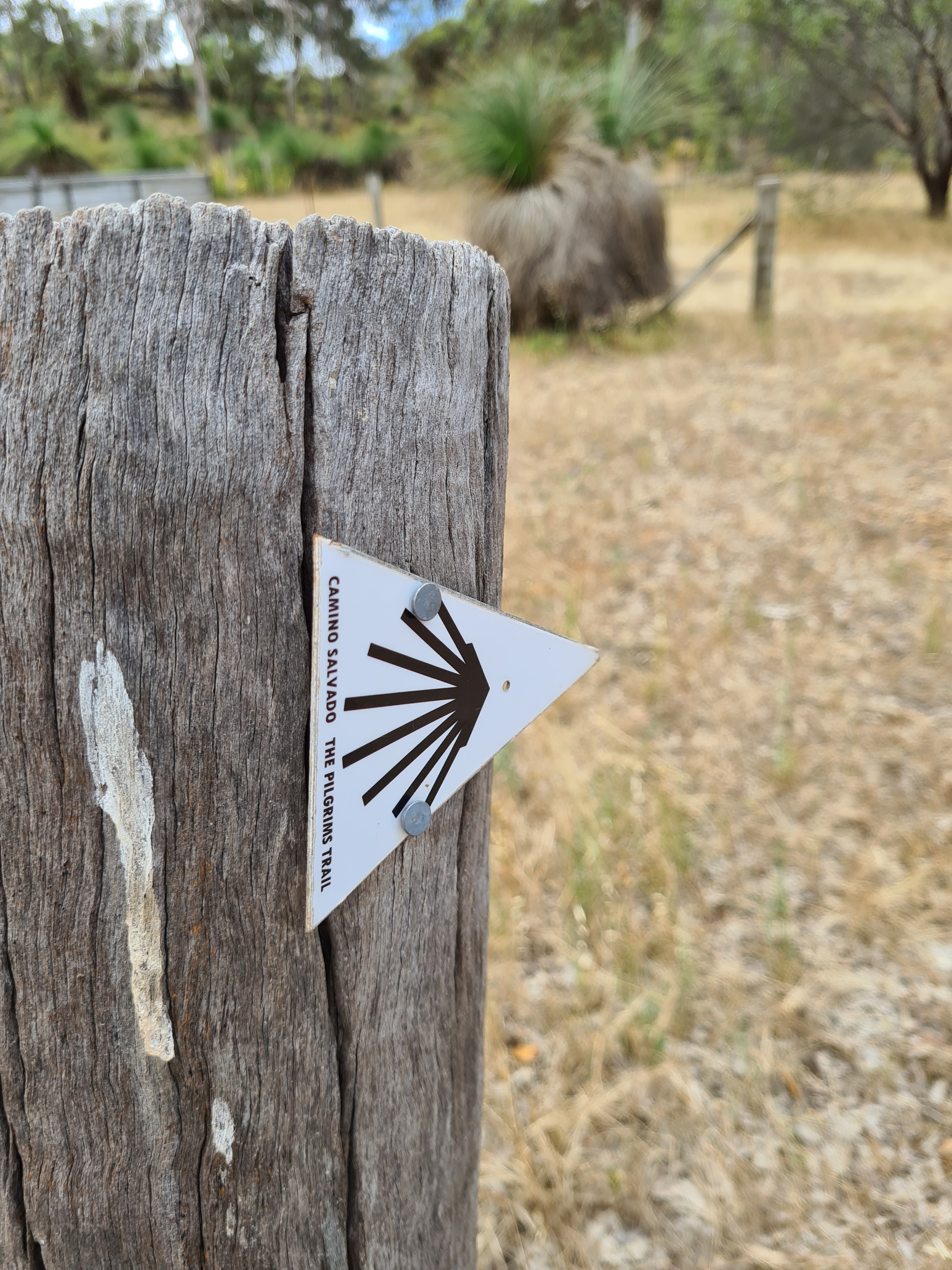
Follow along the narrow rocky track to Walyunga National Park with the Avon River on your right. Be mindful, NO camping is permitted in the boundary of the aboriginal heritage area as per sign post. 
The picnic area makes for a welcome stop with toilets and tap water available, the tap water needs treating before consuming. If over nighting at the campground notify the ranger as a fee is payable. The basic campground with pit toilet is located near the rangers office, just follow the Pilgrim trail markers. Fetch your water from the picnic area as there is no water tank at the campsite.
There are various other marked trails in the NP that link up with the Pilgrim trail. Study the display board if you wish to explore.
Following the trail markers the trail ascends over rough terrain leading to the NP boundary. On exiting the NP transverse along a gravel road with farmland either side. Continue across the private driveway and climb over the stile into a paddock. For a short distance the trail transverses through a farmer’s paddock, don’t forget to close the paddock gates securely on exiting!!!. Walk down the lane-way to Shady Hills Rd and turn left onto the bitumen road which is very busy with local traffic. At this point there is no trail marker!!! Approaching the Y intersection at Smith Rd cross over and follow along the Bridle track until reaching Chittering Rd. 
For the next 10km the trail follows the busy Chittering Rd to Wilson Rd. If you intend to overnight in the Bullsbrook area then BnB accommodation is really your only option. Peace Be Still www.peacebestill.com.au offers cottage accommodation as well as tent sites. Being off route and if pre booked, trail pick up and drop off can be arranged.
Turn into Wilson Rd then left into Wanaka Rd. Cross the stream and if flowing fill up the water bottles, this is the last reliable water source. Make your way up the gradual ascent to the Avon NP where the track flattens out. It is possible to find a cleared area to pitch your tent if you have chosen not to overnight in Bullsbrook.
Now just follow the gravel vehicle track straight through the bush following the trail markers. Don’t be tempted to veer off on adjoining tracks. About midway along a sign indicating a campground points right, this will take you well off route and add extra kms. Be aware this area and the Julimar Forest is very popular with 4 wheel drivers and dirt bikers. Exit the NP and continue on Plunket Rd. There is a cleared area opposite a farmer’s gateway along Plunkett Rd that is ideal to set the tent up.
At the T intersection of Plunkett Rd and Julimar Rd, turn left and about 1km along a trail marker directs you across the bitumen road into the Julimar forest. From here just follow the trail markers through the forest to Dewer Pool Rd. There is an obvious cleared camping area to the left just after crossing Julimar Rd.
At the northern end of Julimar forest just before Munyerring Spring Rd there is another popular camping area. On arriving at Munyerring Spring Rd veer right and continue on to Dewer Pool Rd. Just before Dewer Pool Rd there is a dilapidated three sided tin shed where it is possible to set up camp in a cleared area. After turning left onto Dewer Pool Rd about 300mts along a trail marker points you across the bitumen road and back into the bush following along a very rough eroded gravel track. There are good spots to tuck the tent in amongst the lightly treed area.
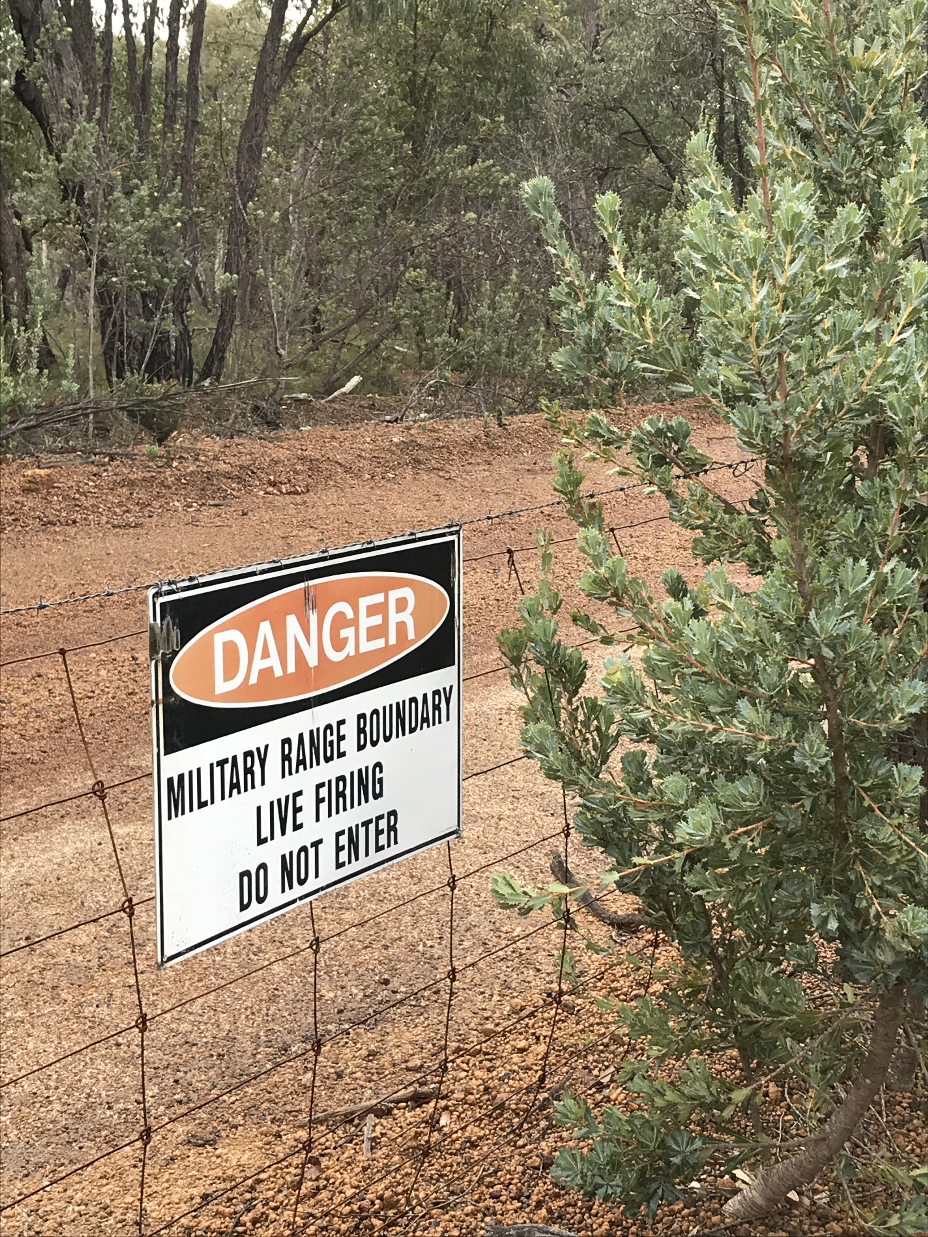
Continuing along the gravel track signage alerts you have reached the Bindoon Military boundary fence. Veer right and follow the pilgrim signs until the trail markers directs you on to a bush track.
Coming to a paddock where there is no trail marker, turn left and follow the paddock fence line until the trail markers reappear. Arriving at the ‘farmer’s paddock’. You can proceed through the open gate passing by the farm house to Old Plains Rd IF you have made prior arrangements with the farmer. (DM if you require phone number). Alternatively follow the trail markers straight ahead weaving along a narrow track with paddocks either side to Buligans Rd where the trail continues left onto Old Plains Rd.
Within this area Carrah BnB http://www.carrah.com.au is located and offers cottage accommodation, tent pitching along with track pick up and drop offs. Just contact prior to hike to make arrangements. Now on Old Plains Rd there are good spots on the side of the road to pitch your tent. A farmer, Neville Clarke welcomes hikers to camp in an area he has cleared at his front gate, a courtesy call is all that is needed. (DM for phone number). From the intersection of Pither Rd and Old Plains Rd Neville’s gateway is 5kms which leaves 35 Kms to New Norcia. Camping within the boundary of the nature reserves that you pass is not permitted.
Cross over Callingeri Rd and continue on Old Plains Rd. Reaching  the Great Northern Hwy turn right and for 5kms it’s a battle with trucks, caravans and general traffic flying along in both directions as you walk along the hwy shoulder into New Norcia. There are plans underway to avoid the highway but for now it remains the highway challenge.
There is a website to view http://www.caminosalvado.com
The Camino Salvado Facebook page features independent hikers adventures and provides a great source of information with opportunity to put forth questions.
OPTIONS
Join a Camino group for a supported hike. Refer to website.
Independent hikers can organize their own support vehicle to carry supplies and either wild camp or stay in BnB accommodation.
Alternatively independent hikers have the option to stake out intended wild camp spots and stash water supplies pre hike. Essential that the empty containers are collected post walk. There are a few streams but flowing water is unreliable. No trace principles definitely apply.
For private hiking operators that conduct fully supported guided treks, simply google.
OUR TREK
Our trek started the week prior with us dropping our water supply off along the track at intended camp spots. The 10litre containers were labelled with contact details, expected arrival date, requesting no one remove the water and that we would be returning to collect the empty container. Placing the water containers well back from the track we covered containers with fallen branches and crossed our fingers.
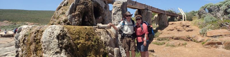
Ian and I started our walk from Bells Rapids and despite the winter sunshine the air was crisp. Crossing the bridge, we made our way along the track towards Walyunga NP with the Avon River slowly flowing by.


Many others where out walking or running with some on the river kayaking. The Avon River is home to the Avon Decent for kayak enthusiasts. Arriving at the picnic area we pondered awhile chatting to a few day walkers before perching on the rocks to watch the flowing river twist and twirl around and over the rocks.


After studying the display board indicating the other walks within the NP we opted to follow the black boot which rejoined the pilgrim trail at the NP boundary. Huffing and puffing our way to the top of the ascent we paused to capture the views that stretched as far as the ocean.


Leaving the NP boundary we also left the crowds behind as we pushed on along the gravel track which was well sign posted. Spotting a good sitting log Ian called a lunch break. Whilst enjoying a cuppa the tranquility of the bush was gently settling over us. Feeling refreshed we continued on shortly arriving at the well known ‘locked gate’. With a degree in unlocking of a farmer’s gate being required we were pleased to see a stile had been built since our last visit giving much easier access to the paddock. A short walk through the private property had us leaving through gates into the lane-way leading to Shady Hills Rd. The lane-way was dotted with kangaroos darting about as we obviously had disturbed their grazing time. Now in a residential area we continued along the bitumen road stopping at the community bus shelter that was decked out with a book exchange, fresh produce and community info. Arriving at the Bridle Path we shared the sandy path with a few out on horse back. Once off the Bridle path we set up camp for the night after a great walk. 26kms


Barely daylight, we woke to some very cheerful birdlife. Ian suggested we roll out of the tent and get an early start to which I grumbled about as I reluctantly unzipped the sleeping bag. Packed up we headed along a very busy Chittering Rd. Despite the traffic whizzing by the lush green paddocks with grazing cattle had our attention. Arriving at Wilson Rd we sat in the bus shelter relieved we had survived the battle with the traffic. With our fill of almonds and beef jerky we pushed on leaving the bitumen road and farmland behind. Veering onto Wanaka Rd, we crossed the stream and made our way up the ascent. It wasn’t long before pausing to catch our breath and enjoy the views of the valley below.


Eventually we reached the entrance to the Avon Valley NP but before continuing on Ian undertook a bit of maintenance work and pounded a fallen pilgrim sign back into the dirt. The large puddles of water on the gravel road indicated there had been significant rainfall, Ian suggested we could have drank from the muddy puddles. I’m resilient but I wasn’t that keen on the idea. Quite a few vehicles drove through with one guy offering us a ride as he thought we were stranded. He couldn’t get his head around why anyone would be walking to New Norcia. He wondered if we owned a car!!!


After a relaxing break we continued on until reaching our wild camp spot tucked in amongst the shelter of trees on Plunkett Rd. Phew, the water stash was exactly where we left it. Taking our time to set up camp was hastened by a few spots of rain that quickly turned into persistent light rain. After a solid day hiking we weren’t objecting to an early night. 26kms


Waking up to the light pitter patter on the tent roof we prepared for a damp pack up but as luck had it by the time we rolled out of the tent the rain had ceased. On our way down Plunket road we were greeted with a rainbow stretching over the paddock, nature putting on a beautiful display. Continuing on with empty water container in hand with intentions to stash it closer to the main road for collection a woman heading off to work pulled up. After a chat she offered to take and dispose of the empty water container. At Julimar Rd we opted to veer right and walk down to Hein Rd where we entered the Julimar Forest. The actual Pilgrim Trail veers left and enters the Julimar Forest as indicated by the signage. A few groups of dirt bike riders had us jumping off to the side as they sped along stirring up the dust, certainly looked like a lot of fun. Rejoining the official Pilgrim track we ambled along in beautiful winter sunshine without a worry in the world. There were some folk set up in their camper enjoying the bush serenity for the weekend.


Walking along Munyerring Spring Rd was a deceivingly steady ascent but one foot after the other along the thick gravel road eventually had us arriving at Dewer Pool Rd. We took a break and poked around at Sid’s or Fred’s shed, not sure who’s shed it is. Turning onto Dewer Pool Rd we walked aprox 300 metres then crossed over the bitumen road onto the gravel track which was partially obscured by the overgrown vegetation. Stopping to chat to a couple of cyclists we enjoyed listening to their adventures on bike. With a hop, skip and a jump we arrived at our intended camp spot and once again relieved to find our stash of water. It was a beautiful evening as we perched on a log enjoying our evening meal. In the stillness and silence of the bush we watched the sun slip away for another day. 28kms


I found myself humming ‘Oh what a beautiful morning…..’, that’s what we had woken up to. While Ian was busy packing up camp, I was totally mesmerized by the beautiful sunshine filtering through the trees, the branches dancing in the light breeze whilst the birds were fluttering about whistling a merry tune. Ian’s voice broke my moment calling to me to do my bit towards packing up, fair enough as many hands do make light work. The rough, eroded bush track lead us up to the Bindoon Military Grounds with very clear signage not to enter. Deciding not a good plan to scale the fence and walk on the better surfaced road, we stayed on our side of the fence and endured the rough eroded track..


The well signed trail hugged the military fence line until eventually veering off onto a bush track. A four wheel drive slowly motored along, the driver inquiring had we come across any wild pigs. Whether its legal or not there is some pig hunting in the forests which indicates the use of firearms and dogs are let loose in chase of the wild pigs. Clearly we were in wild pig territory as Ian pointed out where pigs had dug up the ground and further on empty rifle cases and shot shells lay on the ground. Just a reminder to all to be aware.


Arriving at another ‘farmer’s gate’ we proceeded through the paddock having gained prior permission. Now on Old Plains Rd and passing by the salt pans which were relatively dry we knew our campsite was near. After a solid days walking we were ready to set up camp. What we weren’t expecting was a mosquito infested area. Frantically swatting mosquitoes we grabbed the water container and high tailed it out. With the added 10 litres of water in hand we headed off in search of another spot to pitch the tent. Coming across a clearing amongst some pine trees we pitched the tent and settled in for the night. 26kms


Waking to a much cooler morning we got about packing up. A ute drove by and having noticed us reversed back. Neville Clarke a local farmer was well versed in the history of New Norcia and Dom Salvado. We listened eagerly as he shared the history. Not far from where we had camped the remnants of a water well existed being the area where Dom Salvado would stop to water his oxen. Apparently Old Plains Rd is one of the oldest roads in WA and we were walking on this slice of history. Neville informed us we could have camped in a cleared area at his gateway, if only we had known. Offering to take our empty water container, he headed off for his days work. With the moody sky above we set off for the day. Not far up the road a cyclist hit the skids creating a spray of gravel which he was impressed with but not so us as we wore the spraying gravel. He had caught the morning bus to New Norcia and was cycling back to Perth with an overnight stay at a BnB.


The long haul down Old Plains Rd seemed endless but no point complaining as it was part of the trail. Ian likened it to the Meseta known for its lack of scenery on the Camino de Santiago in Spain. Old Plains Rd being similar as a long flat gravel road that went on and on and on. Despite this I was entranced by the farmland either side of the road which had me racing back to my childhood remembering life on the farm. Eventually catching up to Ian I shared my thoughts which provoked much conversation between us as Ian was also reliving childhood memories of farm life. The inward journey of a camino walk was ignited.


Passing by a couple of nature reserves we then crossed the very busy Calingiri Rd with the sign post highlighting 22kms to New Norcia but not today as we had walked enough kms. Finding our camp spot for the night we set up in a clearing well off the road. Clearly a well used gravel road as a few cars flew by stirring up the dust. After an enjoyable meal, cuppa and chat we crawled into the tent and settled down to a peaceful nights sleep, so we thought. As darkness fell, our drifting off to sleep was abruptly disturbed with the slamming on of vehicle brakes. The vehicle entered the paddock opposite with a spotlight darting about. Before long gunshots were heard, obviously a farmer culling the wayward foxes. 24kms
A light shower of rain overnight had dampened the tent but not our spirits for the last 15kms into New Norcia. Strolling along I asked Ian his thoughts. To which he replied ‘am I going to have a hamburger or a pie at the roadhouse’ fair enough. Our homemade dehydrated food is very enjoyable and we certainly eat well on the trail but nothing beats that end of hike feast of carbs and fat!!!!
For me my thoughts had wandered towards the Pilgrim Trail. It certainly wasn’t one of our most challenging hikes by a long shot or scenic but we both had really enjoyed the solitude, serenity and simplicity of the bush and farmland. Having walked the Camino de Santiago in Spain with the masses of people passing through villages, towns and cities there was a lot going on and at times it was chaotic. Here it was just us strolling through the beautiful Australian bush and farmland. I struggle to find words to describe the depth of peace and tranquility that I was experiencing as well as love and gratitude for our beautiful country.
Before we could see the Great Northern Hwy the cars and trucks could be heard flying along. With the last 5 kms stretching along the Hwy Ian suggested I exchange my daydreaming for awareness of current conditions. I shuddered at the thought of riding a bike and having to contend with cars, caravans and B- triple trucks as they whizzed by.


Out of the blue the temperature dropped and the heavens opened up, thankfully it was short lived but heavy enough rain to drench us before we could don our rain jackets. The bridge work leading into New Norcia was well on the way to being finished. Hurdling the fence we walked along the old road into NN carefully steeping over the collapsed bridge. The sun popped through the clouds as we made our way down to the Abbey church. Venturing into the empty church our footsteps echoed from the wooden floor as we wandered around. It certainly didn’t compare to the structural grandeur of the cathedral in Santiago de Compostela. Bishop Dom Salvado is entombed in the church at New Norcia whilst St Peter is entombed in the cathedral in Spain. When walking the Camino de Compostela we stopped at the small village of Samos where Bishop Salvado originated from. Br Michael took us on a tour of the elaborate monastery, he was aware of the work Bishop Dom Salvado undertook in Australia. Rather surreal to have visited the monastery in Spain where Bishop Dom started his ministry and now be standing in the church where Bishop Dom Salvado was laid to rest at the end of his ministry life.15kms.


Leaving the church we wandered up to the roadhouse to enjoy our end of hike feast. With our fill of carbs and fat along with the purchase of freshly baked New Norcia bread we wandered around the museum and explored the other buildings. The elaborate hotel, which is operational was built in 1920 for the pending visit of the King of Spain, apparently the visit never eventuated.
With our lift back to Perth arriving we headed home feeling spiritually fulfilled and enriched for having adventured through the bush along the Camino Salvado Pilgrim path.
Until next yarn, happy hiking
Bernadette and Ian

Hi Hikersauruses. Great to see another update. Sounds like all is going well with you Bernie.
All the best
Dennis H
LikeLiked by 1 person
Good to hear from you Dennis. Yes life is great especially on the hiking track. Just need to dedicate more time to writing.
LikeLike
Great to follow your journey & very informative for the likes of myself as I plan to do this walk 2021 or 2022 depending on the likes of Covid etc. Bernadette & Ian great reading & good commentary which in turn will make it easier for myself & others in due course, thanks for sharing your trek.
LikeLike
Hope you find this helpful when planning your walk. We spent much time discovering this trail as there isn’t much info for independent.
LikeLike
Although not on the Camino Frances, you still had beautiful views on this Camino … love your photo’s and commentary about each day. Keep hiking (and posting) ☺️.
LikeLike
Glad you enjoyed the write up. Very different Camino compared to Santiago de Compostella and the Le Puy.
LikeLiked by 1 person