Covering a distance of 135kms (give or take a few kms) the Cape to Cape trail stretches between Cape Naturaliste (Dunsborough) to Cape Leeuwin (Augusta) meandering along the Indian Ocean and through the Boronup forest. For hikers there is no entry fee to explore the lighthouses.


Maps, guthook app, guidebooks and a website http://www.capetocapetrack.com.au are all available with relevant and essential information to peruse before setting foot on the track.


Suggested time to hike is between autumn and spring. During the winter months with increased rainfall the creeks and sandbar crossings will be flowing and a detour maybe necessary. During the summer months hyperthermia, limited water, potential for bushfires and increased reptile activity need to be taken into consideration. Before setting out check the current weather conditions.


Travelling down south from Perth to start your hike can be achieved by public bus, http://www.transwa.wa.gov.au/ or self drive. If staying overnight in accommodation down south most will accommodate leaving your vehicle on site whilst you are off hiking as well as offer track transfers. Once in the local area public transport, taxi or private transfer companies are available for track drop off and pick up.
Matt Gouvis in Margaret River http://www.mrpickmeup.com.au
Cy Fort in Augusta http://www.southwestdrivingservices.com
The track can be hiked in either direction starting at either cape or jumping on the track at any township or road access point. There is opportunity to hike the track as an end to end, sectional or day walks either independently or by joining an organised group.
Hike intentions registers are located at both capes and all hikers are encouraged to fill in their hike details prior to commencing their hike.


A variety of accommodation is on offer from basic bush camping to 5 star accommodation (refer to website), there’s something for everyone. Bush camping facilities consist of tent sites, water tanks (dependant on rainfall and needs to be treated prior to drinking), composting toilet, picnic table and seat.


Conto camp-ground is very popular during holidays and over long weekends with bookings being essential for hikers. Visit Conto Campground website and book online.
There is no booking for bush camping areas but keep in mind they are also available for non hikers to enjoy so don’t be surprised to walk into a crowded camp site.


There is no water tank at Point Rd campsite. If you are opting to pull up there stroll into Contos camp and fill up your water bottles before continuing on to Point Rd which is 2km further on.
The track passes through some small beach towns (refer to website) giving a bit of light relief from the hiking track and dehydrated meals.
Keep in mind Hamelin Bay runs on bore water with bottled water being well stocked at the caravan park kiosk.


Being located on the ocean the eateries/shops close mid afternoon as everyone is off to catch a fish or wave, living the dream.
Ocean access is available for four wheel drive enthusiasts to enjoy spinning the wheels in the sand and at times the hiking track merges onto four wheel drive tracks in the dunes.


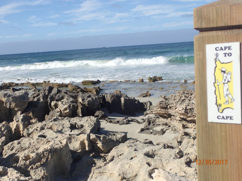
Hikers can expect to walk on well a defined track, trudge through the sand, up and over undulating sand dunes, walk along cliff edges, rock hopping, stepping carefully around the blow holes, negotiating stream and sandbar crossings whilst enjoying spectacular ocean views.


In general the track is well defined and sign posted but be mindful that some markers can be obscured by drooping vegetation, sand build up or simply missing. Beach entry and exit points can be a tad puzzling at times but careful map referencing and drawing on your navigational skills will keep you on the track.


The hiking track is active with wildlife such as snakes, lizards, heath monitors and the kangaroos gadding about within their natural habitat. Generally speaking wildlife will not be an issue if left alone. Ticks, flies and mosquitoes are present in the area.
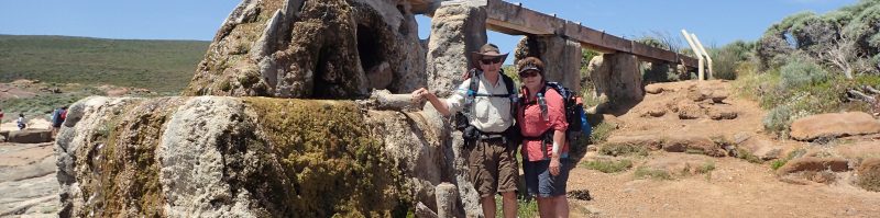
Sight seeing is plentiful with windflowers in bloom, granite outcrops, blow holes, Bobs Hollow, Canal Rocks, Elephant Rock, enclosed bays, Ellenbrook House, spectacular ocean at play and if you are lucky enough migrating of humpback whales, salmon schools and dolphins surfing the waves.


Mobile phone service is intermittent along the track but more reliable in the beach towns.


Be sure to search for personal blogs and tune into you tube as much information is available from other hikers personal adventure on the Cape to Cape.
A write up of our adventure hiking the Cape to Cape to follow.
Until next yarn, happy hiking from Bernadette and Ian

Hi Bernmeister
Great to hear from you glad your still hiking away furiously. Pictures wonderful and story up to your usual standards. Have a great time. Best wishes to you and the Cake Master , Ian.
Dennis
Sent from my iPhone
>
LikeLiked by 1 person
Thanks Dennis, good to hear from you.
LikeLike